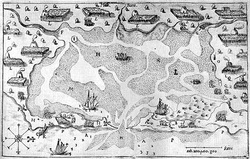
The Nauset Archaeological District, within the southern portion of Cape Cod National Seashore was one focus of substantial ancient settlement since at least 4,000 BC. Indians at Nauset Harbor practiced farming and fishing. Farming was simple, using stone hoes and fire-hardened wood tools to work the soil, but rewarding. French explorers and the early English settlers report crop surpluses. In fact, the early Pilgrim settlers purchased corn and other crop foods from the Nauset Indians during the early years of their settlement at Plymouth, just across Cape Cod Bay. One of the means of fishing can be seen in the upper right corner of the map of Nauset by Champlain (Figure 1), which shows a conical weir constructed of saplings and grass rope, designed to capture fish swimming from the marsh into a pond. Radiocarbon dating and information indicating the season in which different species were collected or hunted, based on studies of the shellfish and other faunal remains from ancient shell middens, indicate that people lived here year-round.
The first written account of the area was by Samuel de Champlain, who sailed in on July 21, 1605, and saw a bay with wigwams bordering it all around. He went ashore with some of the crew: “before reaching [the Indians’] wigwams, [we] entered a field planted with Indian corn…[which] was in flower, and some five and a half feet in height. ... We saw Brazilian beans, many edible squashes…tobacco, and roots which they cultivate … .” He also described the round wigwams, covered by a thatch made of reeds, and the people’s clothing, woven from grasses, hemp, and animal skins. As the expedition cartographer, Champlain has left us an informative map of the Nauset Harbor area (Figure 1). Unfortunately, the visit to Nauset ended after four days with a fight between the French and the Indians in which one Frenchman was killed.
Francis P. McManamon, National Park Service
